Page summary
OME 2 Case Studies
Open Maps For Europe 2 (OME2) is developing a new production process and technical specification for free-to-use, edge-matched data under a single open licence. Authoritative 1:10 000 scale data for 10 countries will be delivered via the user interface built by the award-winning Open Maps For Europe Project.
OME2 is also enhancing the five existing Open Maps For Europe datasets including the Open Cadastral Map; EuroGlobalMap; and EuroRegionalMap.
Find out how the OME2 harmonised high-value large-scale data prototype and enhanced datasets are delivering value to users in the public and private sectors as well as academia.
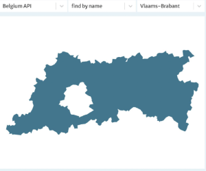
OME2 Project and Nazka Mapps bring boundaries into the open to show benefits of harmonised data
Open PDFThe OME2 project is co-funded by the European Union. It is being delivered by a consortium comprising: EuroGeographics, the not-for-profit membership association for Europe’s National Mapping, Cadastral and Land Registration Authorities; National Geographic Institute, Belgium; National Institute of Geographic and Forest Information, France; Hellenic Cadastre; General Directorate for the Cadastre, Spain; and Cadastre, Land Registry and Mapping Agency, The Netherlands.
Views and opinions expressed are however those of the author only and do not necessarily reflect those of the European Union or European Commission. Neither the European Union nor the European Commission can be held responsible for them.
![]()